Context & History
The Southern Lakes Windriders Club (SLWC) is an organisation of Windsurfers, Kiteboarders and Wind Wingers in the Queenstown area. We currently represent over 178 riders from the area that use the lake and look to the club for advocacy, local knowledge and safety advice. For over 50 years, generations of enthusiasts and professionals have gathered to not only use and enjoy the pristine wind and waters of Lake Whakatipu, but to preserve and protect the stunning environment we all cherish.
The club has a long history of working with local and central government to maintain rigging and launch spots around Lake Whakatipu, ensuring the finite amount of publicly accessible lake access locations are available to not only windsports users but the general public to enjoy the jewel of Queenstown. It’s not only about access, but stewardship, as the club is deeply committed to the environmental care of our spots and maintaining the vegetation around these beaches so everyone can enjoy them.
Each summer, international visitors flock here, international brands film here and locals are out every windy day in summer, spring and autumn for the breathtaking scenery, clear alpine waters and strong mountain winds that culminate for the perfect windriding conditions.
Homestead Bay is a core area in our club’s history. It is the primary area that is locally accessible, has world class wind and waves, and is one of only two safe spots to learn on Lake Whakatipu (the other being Kingston Beach, that only works for a short period of time and during specific conditions, with katabatic winds in April/May). The long beach that allows a safe area for learners to get out of the water combined with the uninterrupted, consistent winds make Homestead Bay the primary area for windriders locally.
We wish to submit our feedback to the Southern Corridor plan, that comes from a long history of using the lake, a deep understanding and knowledge of the local weather conditions in this area and a concern for the environmental mismanagement of the land through intensive, rushed and ‘fast-tracked’ development..
We would like to split our feedback into the following chapters:
Protection of Lakeside Reserve & Launch Area by Jonty Norton
Opposition to lakeside development & marina by Jonty Norton
Environmental Concerns & Wastewater Concerns by Dr Brian McGlynn
Opposition to RCL Homestead Bay Intensive Development by Jonty Norton
Quotes and letters from notable professional windsport users by Tarn Pilkington
Chapter 1 - Protection of Lakeside Reserve & Launch Area
The club wishes to state that we are in favour of preserving the Homestead Bay Lakeside Reserve in it’s current state shown in Figure 1. We are collectively against development on Lakeside Reserve land in any form.
Figure 1. Homestead Bay Lakeside Reserve
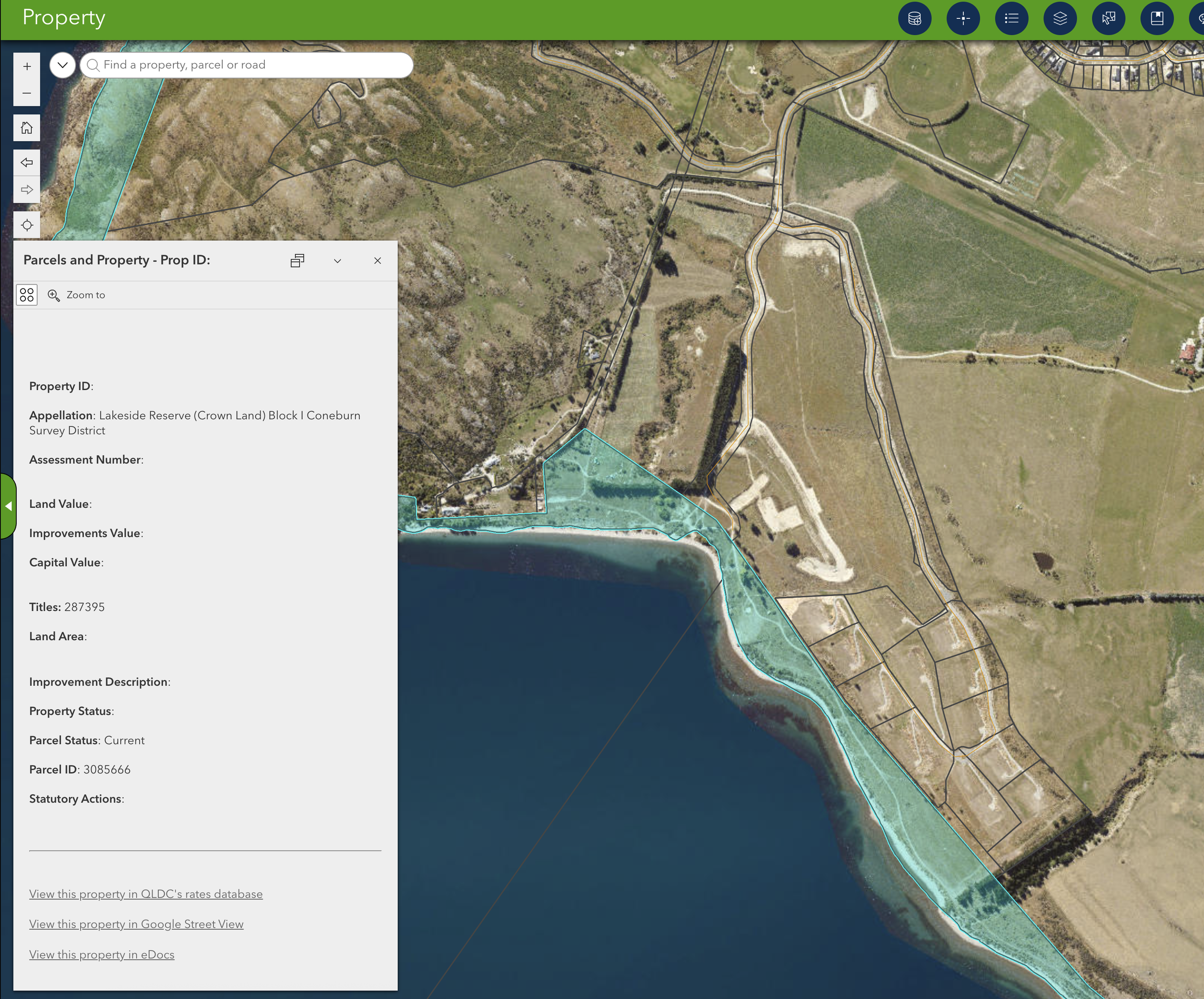
Source: Queenstown Lakes District Council Map Navigator - ArcGIS
However, understanding if the land shown in Figure 1 that is currently managed by LINZ is to be managed by the QLDC we wish to protect our current access and advocate for the area to be designated a parks and recreation area, and have recommendations that will ensure safe access for the public and windriders in the area. These are to be discussed below:
Dedicated Launch and Rigging Area - clear of obstacles and structures upwind
Parking area for windsports users nearby to the launch site
Setback area of any amenities on the lakeside
Advocacy against any highrise buildings on the lakefront that will disrupt natural windflow
Figure 2a. Homestead Bay Lakeside Reserve - Southern Lakes Windriders Current Use
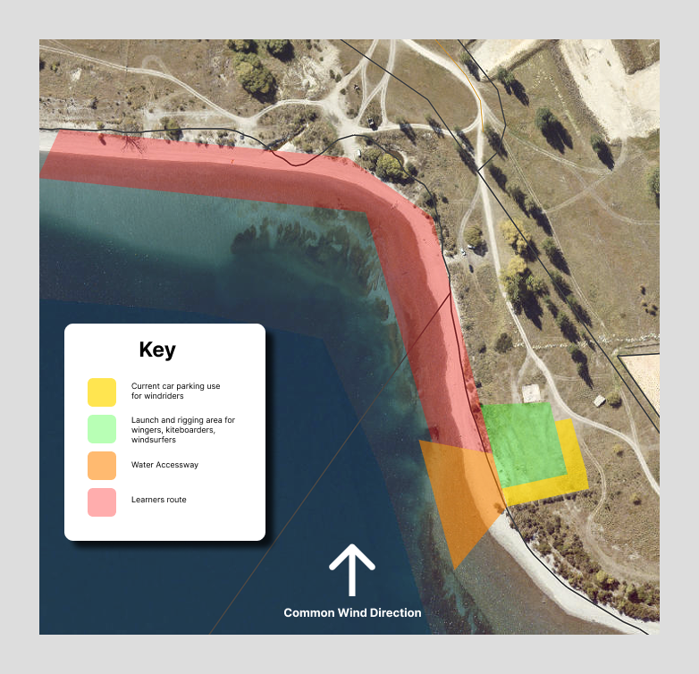
Source: Southern Lakes Windriders Club
For the council to fully understand our current use, we have set out Figure 2. The coloured areas indicate how the club currently uses the area of Crown Land. As a club we have a set of rules of where to park and launch in order to do this safely. We understand that as the area grows in popularity there will need to formalise a dedicated parking and launch site with public signage to continue to practice our sport safely. The yellow area indicates our club-agreed current parking area at Homestead Bay, this is out of the launch and rigging site and enables solo kiters to launch their kites safely. The green area is the minimum area needed to safely launch a kite. The orange area showcases an uninterrupted area to safely walk to the water without trees, bollards, paths or other amenities that can be dangerous obstacles while carrying wind equipment or being connected to kites. The red area indicates the learners walking route - as the wind naturally blows down the beach this is the area whereby learners walk back to the launch and rigging area if they are unable to hold their position upwind.
Article 1a - Dedicated launch & rigging area (clear of any obstacles/buildings upwind & downwind of launch area and riding zone)
In order to practice our sport safely, there are minimum requirements to do so. We need a dedicated and clear launch area that has a minimum 50 meters in all directions (especially downwind), clear of people, trees, powerlines and other hazards. As members and kiteboarders are launching kites that are up to 14m2 in area, gusty winds can quickly change the direction of the kite without warning and the need for a clear launch site is critical. Hazards such as bollards have been known to create injury or death as shown in this example from Tauranga in 2019 and downwind trees close to our launch site are hazards as kites can get tangled in them. The launch area also needs to be clear of any structures up and downwind.
Shown in Figure 2a above is our current launch and rigging area for kiteboarders, wingers and windsurfers and this is a bare minimum.
Upwind - Clear of obstacles and buildings - In Figure 2b, the blue section in the bottom right hand corner of the graphic indicates the upwind location of the foreshore that would affect the flow of wind directly to our launch spot. Any buildings, structures or trees in this area would disrupt the natural flow of the wind, create gusty conditions for launching and increase the risk of an injury or death to kiteboarders.
Figure 2B. Homestead Bay Lakeside Reserve - Southern Lakes Windriders PROPOSED Use
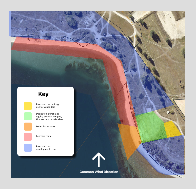
Source: Southern Lakes Windriders Club
Figure 3. Homestead Bay Lakeside Reserve - Prevailing wind direction, turbulent wind area and main kiting area
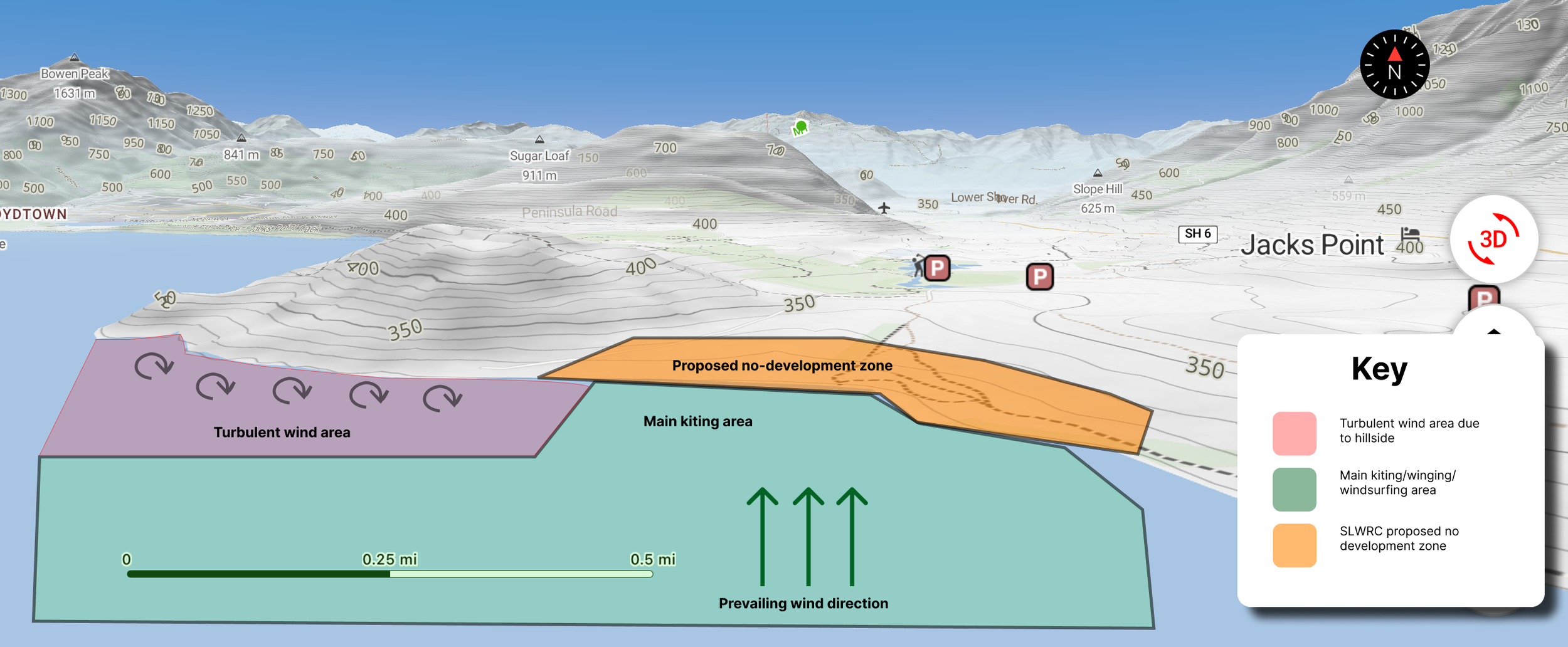
Source: Outmap & Southern Lakes Windriders Club
Downwind - Clear of obstacles and buildings- Although downwind of the windriding areas, downhill obstacles, structures and land topography can both severely disrupt the windflow to areas upwind of it, and also increase the risk of entanglement, injury or death. In the turbulent wind area highlighted in red in Figure 3. there is a natural wind shadow due to the inclination of the hill downwind. In turn, the wind bounces back off the hill, changes direction without warning and creates gusty conditions that make it difficult to continue upwind. This can be a risk to new windriders in the area that don’t fully understand the effect of the windflow from the hill as their kite can drop out of the sky, they can’t get back on foil and have to swim in - sometimes a dangerous situation with fading light and cold lakewater. Whether it’s a hill or a building - both can disrupt the natural flow of wind. The club advocates for a no-build zone in the LINZ managed foreshore area highlighted as a proposed development in orange in figure 3, a setback of building 300m from the shore and no large trees nearby to the launch area. We are also against high-density development so close to the shore.
Case Study - Big Bay South Africa
Big Bay South Africa is a prime example of intensive development too close to shore disrupting natural wind patterns. Big Bay was the premier kiteboarding destination in South Africa and was the inaugural location to host the Red Bull King of the Air - the world championship Big Air competition. With rising popularity of the sport, many kite shops and schools set up locations on this beach. However due to the development of highrise buildings being built directly in the flow of the Cape Doctor trade winds - this affected and disrupted the natural wind flow to the point that it was not safe to hold the competition there anymore. It was a prime example of biting off the hand that fed them.
Article 1b - Parking area for windsports users nearby to the launch site
It is important to ensure we have a dedicated parking bay nearby to our launch zone. In order to ensure that public cars are not crossing through our dedicated launch zone and therefore increasing risk of injury to themselves or windriders during the process.
We fully understand and support that windriders are not the only users of this area, and during non-windy days Homestead Bay will become an important place to relax nearby to the water. As the area grows in popularity it's important we can manage it in harmony, we want to ensure it stays a mixed use public recreation area, not only accessible to all, but ensuring both members of the public and windriders stay safe.
The current parking situation is outlined in Figure 2a. and highlighted in yellow. Windriders park on the eastern and southern ends of the launch zone. This ensures that cars are out of the way of the launch zone (not downwind of kiters launching their kites) or crossing lines during setup. In its current state, these rules have been implemented by the club and any new riders to the area are inducted into this zoning. We are totally supportive of members of the public using the area, but meanwhile we also need to uphold the safety of our riders. So when a member of the public accesses this area, we kindly explain the parking zoning and ask them to not park within our launch area as it can be a danger for the themselves, for our riders and it can damage equipment that is currently being set up (kites can have up to 22m lines that need to be laid out).
As the area grows in popularity, we need to formalise zones to ensure the continued safety of the public, our riders and our equipment. Our suggested plan is outlined in Figure 2b - what we suggest is a parking zone to the east of the launch zone, that will ensure that no public cars will be in, upwind or downwind of our launch zone or affecting the natural flow of the wind. We also suggest that there is a setback of any amenities (parking bollards, bbqs, bike paths etc) from the launch zone to ensure there are no obstacles in the way for launching.
What we don’t want to happen is a mixed use zone whereby cars have free reign to park within our launch area (like it currently stands); this will be harder to police and enforce as the area grows in popularity.
It is important to note that although the club has been registered as an ‘affected party’ in previous resource consent applications, yet current landscaping plans for the development of the Homestead Bay area have not sought to consult with local windriders. This can be shown in past plans with parking on one side of the marina and our launch side on the other. With boards, foils, kites and pumps having to be carried by hand, proximity of parking to the launch spot is incredibly important. It was virtually impossible in some of these plans to walk through a private marina with boards, foils and equipment.
In Figure 4. below, although supposedly a draft, it has given car parks and a marina the best view. Where is the greenspace setback and room to enjoy the lakeside?
Figure 4. Proposed Local Centre in Homestead Bay
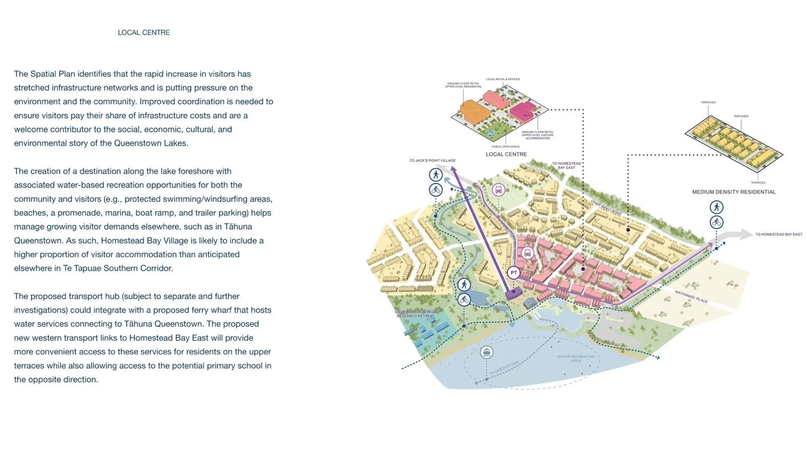
Source: QLDC Let’s Talk - The Southern Corridor
Article 1c - Setback area of any amenities on the lakeside
We recommend a mandatory minimum setback of 300 m between any lakeside amenities (e.g. seating areas, parking, bollards, pathways, other structures) and the launch zones for wind-based sports.
This buffer is essential because:
Safety: Kites and windwings - especially in strong or shifting winds - can travel unpredictably. Close structures pose serious entanglement or collision hazards.
Windflow Integrity: Amenities placed too near lift or launch zones can disturb airflow, leading to turbulent gusts and unsafe launch conditions.
In particular, bollards or benches planted close to the rigging area introduce trip and snag risks during setup- accidents that have occurred in other windsurfing kite sites across New Zealand (e.g, Tauranga, 2019, where bollards caused severe injuries).
We urge the council to commit that any lakeside infrastructure is placed well clear of the rigging and launching zones, with signage and physical buffers to preserve safe wind corridors.
Article 1d - Advocacy against any highrise buildings on the lakefront that will disrupt natural windflow
The SLWRC advocates that no high-rise or multi-storeyed structures should be permitted along the lakereserve foreshore near Homestead Bay.
Evidence from similar global sites (e.g., Big Bay, South Africa) shows that high-rise development directly in prevailing wind corridors seriously disrupts natural wind patterns, making prior world‑class wind conditions unsafe or unusable.
At Big Bay, buildings constructed in the path of the Cape Doctor trade winds eventually made conditions unsafe - and cost the area its international prominence in kiteboarding.
At Homestead Bay, the prevailing alpine wind flows are critical to maintaining safe, reliable conditions. High-rise structures would:
- Create wind shadows, variable turbulence, gusts, and lulls
- Compromise learner safety and reduce predictability for professionals
- Detract from the outstanding natural landscape character, which the Structure Plan aims to protect
Chapter 2 - Opposition to lakeside development & marina
In past plans for the Homestead Bay area, there have been suggestions of building a marina, and although the current plan is rather vague - illustrations suggest such a marina.
The SLWRC strongly opposes any development of the foreshore, any proposed marina and any commercial water-based operators in Homestead Bay.
Such a marina is designed to benefit a few with the expense of many. What is a vibrant playground of wind and waves all through summer, will become unsailable for windriders. It will become empty - with boats of the wealthy few parked there but unable to be used because of the constant wind and waves.
It’s a boat car park for the privileged few, exclusive waterfront access, and the idea that a commercial company (or QLDC) is being paid a fee for people to use that area that should be open to everyone is not benign. What has happened at the Frankton Marina? A few nice shops.. Yes, but due to health and safety and exclusivity noone is actually allowed to enjoy the water from the marina. Who wins - a tiny minority. Who loses? Every local learner and summer wind-lover.
A marina will:
Disrupt the natural beachline and foreshore and interrupt a safe passage for wind learners to learn wind sports.
Benefit a few for the expense of many
Disruption to windflow
Sedimentation
Loss of shoreline habitat
Exclusion of public use
More boat traffic would
Increase safety risks with wakes, collisions and vessel traffic close to windriding zone
Commercial operators would disrupt the calm nature of the area during non-windy days.
The point must be raised that with the strong Katabatic winds and lake swell, marine operations (that will most likely be subsidized by the council) will have to navigate incredibly challenging conditions that will affect and likely cancel regular scheduled operations during summer months as the waves and wind swell are too big to safely navigate in boats.
The lakefront should remain a shared public recreation, sports and leisure zone. Placing community access and environmental integrity ahead of commercial usage.
We would also like to question the economic viability of such marine transport. Where is the data coming from that the workers of Hanleys, Jacks Point and the proposed Southern Corridor are actually working in Queenstown? With many of the commercial operators and offices in Frankton, one would think they are commuting to Frankton and not to Queenstown.
The SLWRC supports Homestead Bay’s designation as a public parks and recreation zone, not a commercial or private enclave. - This aligns with the Structure Plan’s goal of creating green, open spaces and access to Lake Whakatipu.
Share use between windriders and the broader public is not just feasible, it’s ideal - preserving natural character, enabling multiple recreation forms and ensuring safety through clear zoning.
Chapter 3 - Environmental Concerns & Wastewater Concerns - By Dr. Brian L. McGlynn
Notes for Homestead Bay Fast Track – Water Quality focused
The Southern Lakes Windriders Club is an active community of water enthusiasts with decades long interests and stake in the health and vibrancy of Lake Whakatipu, especially Homestead Bay. Homestead Bay has been a focal water/wind sports area since at least the early 1980s and its world class conditions and health could be threatened if the Fast Track Application for Homestead Bay is granted and development proceeds without the utmost care and consideration of the long term health of the area, water quality preservation, and the lake edge environment protection. Our club includes a broad cross-section of community members and professionals with expertise and experience that should be considered and leveraged for the benefit of the region and more specifically this proposed development. For example, the Assessment of Environmental Effects associated with the Fast Track Application could greatly benefit from hydrology, hydrogeology, ecology, and water quality expertise present within the club.
It is clear that the best thing for the health of the lake, local water quality, and the lake margins would be for the area to be preserved in a natural or managed near natural state. However, we acknowledge the development economic pressures that exist throughout our region, the zoning changes that have occurred locally, and the private nature of the land ownership in the area. Therefore, we seek to offer caution where appropriate, alternatives where evident, and guidance where possible on how multiple objectives can be met for the community and the lake margin environment if development is to occur. In addition, we offer and request that our expertise and experience be consulted and leveraged for the benefit of the development and people who care about the lake and foreshore environment.
Conservation of tributaries (including ephemeral and intermittent streams), wetlands, and broad lake margins is paramount to maintaining the integrity of the local environment around Homestead Bay. Water flow, both surface and underground, connects even distant portions of landscapes to downgradient receiving waters, carrying pollutants, pathogens, and excess nutrients to the margins of Lake Whakatipu. Therefore, type, density, and location of development and where it is located in a larger landscape context can determine its degree of impact to local water bodies as mediated by the management of stormwater and treatment and disposal of wastewater.
Dr. McGlynn, an internationally recognised Hydrologist and Biogeoscientist, and multiple members of the Southern Lakes Windriders Club have read much of the materials submitted as part of the Fast Track Application and include some of our concerns with respect to the plans in the application and Assessment of anticipated Environmental Effects below.
From the perspective of lake margin, water users and the health of Lake Whakatipu and its nearshore areas, wastewater and stormwater treatment and disposal are of paramount concern given the surficial hydrology and groundwater hydrology of the area and large numbers of local community members recreating in the foreshore. Regular foreshore users range from multi-generational family groups swimming and picnicking in settled weather and to dozens of windsport enthusiasts in and out of the water and lake margins in all seasons of the year when the wind picks up (which it often does).
The larger landscape context of the high density proposed development area and proposed wastewater disposal areas is the mountain front between the Remarkables and Lake Whakatipu that is comprised of the alluvial, colluvial, and lake deposits and history of glaciation and glacial till/outwash deposition that contribute to a complex and preferential subsurface water flow network from the development area into Lake Whakatipu. This has similarities to other areas worldwide where Dr. McGlynn and his students/colleagues have conducted detailed scientific research and water flow and biogeochemistry.
The Windriders Club appreciates that efforts appear to have been made to locate land treatment areas (wastewater effluent disposal areas) largely away from the lake edge and nearshore areas, except for Land Treatment Areas (LTAs) HO-1, HO-2a, HO-2b, HO-3, L that are closest to the lake. These areas should all be relocated farther from the lake and away from all tributaries. Although distance from the lake alone will not ensure that wastewater pollution of the foreshore and lake edge groundwater does not occur, it does give enhanced time and distance for natural attenuation and dilution with area groundwater. In addition, land application rates should be minimized and land application areal extent maximised. In other words, we request and strongly recommend that land application rates of wastewater be reduced by increasing the land area used for wastewater disposal.
Wastewater effluent application to land for developments of this size and intensity in poorly developed alluvial, glacial, and lacustrine deposits and shallow topsoil results in loading of shallow subsurface materials poorly equipped to utilize and process wastewater leading to shallow soil and regolith nitrogen saturation. This means that there would be little nutrient processing (like excess fertilizer) in rapidly moving groundwater transported through preferential flowpathways and sometimes through coarse, relatively deep alluvium and colluvium of the alluvial fan and glacial deposits between the proposed development LOAs and the Lake Whakatipu edge where groundwater discharge to the lake margin is expected to occur.
LTAs (land treatment areas) 1,2, and 4 present additional concern over their potential hydrologic connectivity to surface drains (e.g. modified Middle Creek) and the perennial to ephemeral Māori Jack Stream that is already water quality impaired likely exacerbated by Jacks Point/Hanley Farm wastewater and stormwater. Surface and subsurface flows around these areas / sites should be monitored frequently (especially during high runoff events) and at high spatial resolution due to their potential to pollute the lake margins and short circuit slower subsurface groundwater flowpaths. Current monitoring networks and installations and sampling frequency are inadequate to assess the degree of impact from the existing development and likely strongly underestimate existing degradation.
We believe that the existing and proposed groundwater and surface water monitoring design is insufficient in its spatial layout, depths of groundwater sampling, and surface water sampling locations. Equally lacking is the temporal frequency of water quality monitoring, especially the absence of high flow and storm event sampling of key locations. Therefore, we seek to contribute to the wastewater and stormwater monitoring design to allow for thoughtful development while also working to help protect downstream water bodies, relatively pristine ecosystems, and nearshore recreational users. The individual groundwater and surface water monitoring wells / piezometer depths and locations need to be part of a coherent and well-designed monitoring network to effectively assess wastewater fields, wastewater plume migration and evolution, and lake margin shallow groundwater discharge to both the foreshore and Lake Whakatipu. For example, sampling in the open lake itself (cornerstone of current design) is not a reliable indicator of the seepage groundwater quality entering the lake from the upgradient wastewater fields. Instead, shallow groundwater wells (fully screened over the water table) and multiple depth piezometers (discrete interval/depth groundwater monitoring) in the foreshore and lake margin would allow for accurate and repeatable/reliable assessment of seepage water quality. This is not possible in the open lake, even at the lake edge, due to the vagaries of wind, currents, waves, and mixing dynamics at that instant in time. Open lake water sampling will invariably under-reflect the degree of groundwater and nearshore wastewater contamination that might occur. We offer our expertise and time to help advise/ensure that more effective monitoring be accomplished for the benefit of the development, local ecosystems, and water users.
In summary with regards to wastewater and stormwater, community water/wind sport user concerns include lake margin water quality and nutrient/pathogen loading via deep and shallow groundwater, tributary runoff (stormwater and wastewater) originating from LTAs (land treatment areas). We believe that existing and proposed monitoring and sampling schemes are grossly inadequate in their spatial locations, depths, and frequency of monitoring if developers and the local community seek early warning and avoid further degradation to the foreshore environment and negative impacts on water users and the local ecosystem. We understand that human caused degradation is already evident in Māori Jack Stream and the lake edge as highlighted in included application materials and environmental assessments even with poor temporal resolution sampling and a poor monitoring network design and relatively low numbers of households as compared to what is proposed in this Fast Track application.
Existing degradation will likely get significantly worse even without the additional wastewater loading from the proposed Homestead Bay development due to cumulative nutrient loading and nitrogen saturation over time, preferential flow of shallow groundwater that allows for rapid movement of wastewater to the lake edge, short circuiting of soil wastewater processing by rapid flow to adjacent streams and tributaries. In short, existing degradation is likely getting worse with time even if there is no further development. Therefore, if new development is to proceed, better wastewater and stormwater management will be critical to slowing the degradation of the prized foreshore and lake edge environment of Homestead Bay and Lake Whakatipu.
Currently inadequate monitoring network design and temporal sampling frequency has still managed to capture water quality degradation, suggesting that it could be worse than realised. Therefore, we suggest that developers and local authorities leverage available expertise in the Windriders Club for community consultation/oversight and guidance on nearly all facets of wastewater disposal and water quality monitoring design and execution as well as recreational user / stakeholder experiences.
Conditions giving rise to wind and waves
The wind and waves of the Homestead Bay area are world class for recreational users and water sports enthusiasts. The area is already a destination for the strength and quality of the wind and waves and the spectacular mountain lake setting. In fact, it is world known and on travel lists for water sports and regularly features in advertising campaigns and social media targeting wind sport athletes and recreational users.
Although the area can generate world class wave and wind conditions year around associated with frontal systems (especially southerlies), summer near daily thermal dynamics and southerly front conditions lead to predictable world class sporting environments on par with the North Shore of Maui (Hawaii USA), Hood River (Columbia Gorge Oregon), Cape Hatteras (North Carolina Outer Banks USA) that draw heavy sports tourism from around the world. Lake Whakatipu and the Homestead Bay area can be as good as those destinations and arguably the scenery exceeds almost anywhere in the world. This is a world class community resource to appreciate, promote, and protect.
Local environment and meteorological conditions supporting windsports in the area include southerly fronts all year around but especially in the fall, winter, and spring funnel and concentrate wind flowing north from the southern ocean and plains of Southland to the southern shores of Whakatipu where the wind is compressed between the Hector and Remarkable mountains to the east and Mt Dick, Bayonet Peaks, and Cecil Peak to the west through the Devils Staircase section of the lake resulting in winds that can be in excess of 25-40 knots (45-75 km/hr), generating rolling swell and 2+ meter waves because of the ~27 km from Kingston to Homestead Bay (the southern arm of Lake Whakatipu). These conditions transform a gentle shoreside bay from stand up paddle board and family picnic conditions to one of the top wind and wave sport destinations in New Zealand that is among the best in the world.
In addition to frontal winds funnelled up the lake between the mountains, unequal heating the earth’s surface between the southern ocean and Southland and the interior of the South Island around Queenstown and central Otago results in reliable afternoon and evening conditions that transform calm mornings and mid-days on the lake into a wind and wave sports hotspot where winds can shift from gentle northerlies or calms conditions to 20-35 knots (37-65 km/hr) of southerly thermal wind and rolling waves in 10s of minutes to a few hours that subside after nightfall.
Summer and shoulder season thermals from November through April can be both pure thermal and reinforced southerlies from larger regional flow, giving rise to a premiere wind and water sports resource and destination used by locals and national and international tourists since the early 1980s at least.
________________________________________
Professor Brian L. McGlynn is employed as Hydrologist and Biogeoscientist with e3Scientific, Arrowtown, New Zealand. He is also an Adjunct Professor of Hydrology and Biogeosciences in the Nicholas School of the Environment at Duke University, USA.
Dr. McGlynn is a PhD Hydrologist with expertise in watershed and stream hydrological, ecological, and biogeochemical processes including the impact of development on water quality in mountain environments. He has extensive experience investigating natural and disturbed watersheds, stream networks, and groundwater systems in NZ and internationally.
Dr. McGlynn is currently an Adjunct Professor of Hydrology and Biogeosciences in the Nicholas School of the Environment at Duke University (USA). From 2012 – 2019 he was a Professor of Hydrology and Biogeosciences at Duke University and Chair of the Division of Earth and Ocean Sciences from 2014 – 2016. From 2002 – 2012 he was an Assistant Professor then Associate Professor of Watershed Hydrology at Montana State University. Dr. McGlynn is a member of the New Zealand Hydrological Society, the American Geophysical Union (Hydrology and Biogeosciencessections), and has been a long-term member of the Society for Freshwater Science, the European Geophysical Union, and the Geological Society of America.
Dr. McGlynn continues to be actively engaged in research and application at the forefront of environmental science understanding. He holds the following tertiary qualifications; a Bachelor of Arts in Environmental Studies and a Bachelor of Arts in History from Gettysburg College (USA), and a Master of Science in Hydrology and a PhD in Hydrology from the State University of New York College of Environmental Science and Forestry at Syracuse (USA).
Dr. McGlynn has more than 26 years of experience working in hydrology, biogeochemistry, ecology, soil and geological science, and water quality beginning in 1994. He has served in project director roles since 2002. He has worked across a wide range of environments from the Arctic to the Amazon including Westland, NZ where his PhD research focused on stream water sources, runoff flowpaths, and resultant water chemistry in cooperation with LandCare and NIWA in the Maimai catchments on the east side of the Paparoa Mountains, New Zealand. He has additionally performed hydrological, biogeochemical, and landscape analysis projects for the US National Science Foundation, US Environmental Protection Agency, US Department of Agriculture, Montana State Department of Environmental Quality, US Forest Service, and a number of Non-Governmental Organizations.
Professor McGlynn has taught >13 different university courses focused on water science and management, river and catchment hydrology, water quality, ecohydrology, hydrogeology, and spatial analysis to many hundreds of undergraduate and graduate students while individually mentoring dozens of students through research training and experiential learning. He has served as the primary mentor and advisor for more than 9 M.S. students and 12 Ph.D. students, and 6 post doctoral professionals who have gone on to successful careers at leading academic institutions, consulting firms, and state and federal agency employment in the water arena.
Dr. McGlynn has decades of US National Science Foundation sponsored experience as project director and investigative scientist focussed on the hydrological and biogeochemical effects mountain resort and housing development highly relevant to this Fast Track proposal. He co-authored >5 published papers in top international scientific journals from this work directly related to this Fast Track application. In short, they found that even low density housing and wastewater disposal had profound impacts on mountain stream water quality and ecosystem function. Wastewater disposal in naturally low nutrient environments like Jacks Point and Homestead Bay can have far reaching downstream negative impacts that increase over time as flow pathways become nutrient saturated. Therefore, wastewater and stormwater treatment, management, disposal is critical for maintaining ecosystem health, especially in sensitive environments like Homestead Bay.
Recognition of Dr. McGlynn’s scientific contributions are partially reflected in his impact on international hydrological and biogeochemical sciences. These are indicated by: >11,500 scientific journal citations to >100 of his peer reviewed scientific research papers, an H-index of 55,and an i10 index of 103. An H-Index of 55 means that 55 of his publications have been cited by at least 55 other published peer reviewed scientific journal articles while an i10 of 103 means that 103 of his articles have been cited by at least 10 other scientific journal articles. http://scholar.google.com/citations?hl=en&user=c2iow7sAAAAJ.
Dr. McGlynn has a strong understanding of hydrological processes and how water flowpaths, streamflow source areas, and landscape characteristics impact water chemistry and stream and groundwater quality in ecosystems around the world. Dr. McGlynn has brought this experience and expertise to consulting work in New Zealand and has become intimately familiar with freshwater and wetlands regulations and polices over the last few years and has taught short courses on these topics to NZ environmental professionals.
Dr. McGlynn is familiar with the catchment hydrology, meteorology, climate, and groundwater hydrology of the Whakatipu region and has lived, worked, recreated in the Kelvin Heights to Homestead Bay to Devils Staircase area of Lake Whakatipu since 2021.
Chapter 4 - Opposition to RCL Homestead Bay Intensive Development
The SLWRC also advocates against the Homestead Bay Development by RCL
A project of this size, without proven environmental safeguards, risks contamination of Lake Whakatipu, placing public health, local ecosystems and recreational use of Homestead Bay area at risk of pollution. With the existing systems already overwhelmed and upgrades unfunded, proceeding at this pace risks repeated environmental failures and public health hazards.
We believe:
There is inadequate wastewater and stormwater infrastructure to manage wastewater or stormwater runoff for a development of this scale
Queenstown's Shotover treatment plant is already failing, with emergency discharges of treated effluent into the river - we don’t want this happening near Homestead Bay
There are already concerns in the community that reflect the distrust in treatment quality by the council and its contractors - (2023 cryptosporidiosis outbreak)
Rapid growth outpacing infrastructure capacity
Critical services aren’t keeping pace with the growth (water, transport, community facilities)
Rezoning is approved before infrastructure is ready
Chapter 5 - Quotes and letters from notable professional windsport users
Mike Raper - CBO - North Kiteboarding & North Foils
As Chief Brand Officer for North Kiteboarding and North Foils - a subsidiary of the North Sails / North Actionsports Group - I fully support the Southern Lakes Windriders Club in opposing any development within Homestead Bay that could undermine its world-class wind corridors and pristine natural environment.
In 2018, our company returned North Kiteboarding and North Foils to its roots under the North Sails umbrella, we chose to base our product development, brand operations, and athlete training hub in New Zealand, drawn by the unmatched combination of varied wind regimes, dramatic waves, and the outstanding alpine-lake landscapes like the one and only Lake Whakatipu.
We have filmed multiple global marketing campaigns and product launch videos on Lake Whakatipu - Glenorchy and the world famous in the windsports world - Jardines / Homestead Bay - and have invited pro athletes from around the world to train in this environment for its consistent conditions, accessibility and natural beauty.
My message is clear: Homestead Bay is a world-class wind & wave spot. Any lakeside development - particularly high-density infrastructure or marina structures - will degrade the natural wind flow, compromise safety and sanctuary for water users, and eliminate a site we may well never recover.
This is not just a local issue. For North, built on wind technology and precision, the loss of Homestead Bay would mean losing a key testing ground, a location that is part of our brand DNA, and an athlete training zone.
I give this statement not only as a representative of our brand, but as someone who has lived and witnessed how fragile wind access and shoreline character can be - with ever‑present potential to be permanently diminished.
Marc Jacobs - Red Bull King of the Air 2021, Vice World Champion Freestyle Kiteboarder
I am Marc Jacobs, a professional kiteboarder and athlete with deep roots in both competitive and wind related product-testing environments worldwide. I took home the title of Red Bull King of the Air in Cape Town in 2021 and was Vice World Champion in 2013 for the Professional Kite Riders Association world tour.
Lessons from Big Bay
Cape Town’s Big Bay and Blouberg Strand are among the world’s most legendary wind and wave rich kitesurfing venues - favoured for their consistent “Cape Doctor” south-easterly winds, ideal wave formation, and broad sandy beaches suited both for high‑performance riding and competition. Over time, however, heavy coastal development - high-rise units, commercial structures, and dense beachfront infrastructure - have profoundly altered the landscape. Former grassy dunes are now paved over, public access reduced, and natural wind corridors disrupted.
As someone who not only competed there but filmed promotional and launch campaigns in that setting, I witnessed first-hand how these physical changes degraded riding conditions and eroded the open-access ethos of coastal recreation.
Jardines & Homestead Bay: Too precious to sacrifice?
Can we bring forward what we have learned in Cape Town to Jardines and Homestead Bay - the parallels are real:
These are extraordinary testing grounds. The clean, consistent katabatic lake winds, natural launch zones, and visual clarity is unrivalled globally. And once it’s lost it will never recover.
They attract international brands (Armstrong Foils, North Kiteboarding) who want to film here because of the outstanding natural landscapes,the local community that frequents the spot and of course the world-class windflow.
I have been contacted by the Southern Lakes Windriders Club to lend my voice against any development that compromises this environment. Like Big Bay before it, the introduction of lakeside buildings, marinas, or high-density housing at Homestead Bay threatens to fragment wind coherence, restrict access corridors, and permanently degrade a site that is home to world class natural conditions.
Why This Matters
Wind integrity: Like in Cape Town, physical structures in the wind corridor will disrupt the natural laminar flows riders rely on.
Community access: Once public shoreline turns private or commercial, the access becomes more difficult and daily usage vanishes.
Irreplaceable value: Jardines and Homestead Bay offer conditions that are impossible to replicate elsewhere in the world.
I’m calling upon decision-makers: do not repeat the mistakes of Big Bay. Preserve Homestead Bay as an open, shared, wind-powered playground and not an elite waterfront enclave. For kitesurfing, winging, wind sports and community alike it is too precious to sacrifice.
Marc Jacobs
Professional Kiteboarder
2013 PKRA Vice World Champion, 2021 Red Bull King of the Air Champion
International Team Rider for North Kiteboarding & Brand Ambassador for New Zealand’s wind-sport ecosystem.